Even before summer heatwaves sent temperatures soaring across the west, lakebeds had already begun ceding ground to the cracked, dried earth.
Rings showed around reservoirs where water levels fell to historic lows, verdant hillsides took on brown hues, and trees became tinder in forests primed to burn. The conditions fueled unstoppable fires that grew large and ferocious enough to create their own weather patterns.
But along with the desiccation, there were downpours. Even as states grappled with the effects of a devastating drought, storms delivered heavy rains that caused floods and damaging debris flows.
In the American west it was a year of extremes. Scientists say it is likely just a taste of what’s to come if the climate crisis continues on its current course. “We have known this for a while,” said Steve Ostoja, director of the USDA California Climate Hub. “The question is how extreme is this going to go? What is the ceiling and what is the floor?”

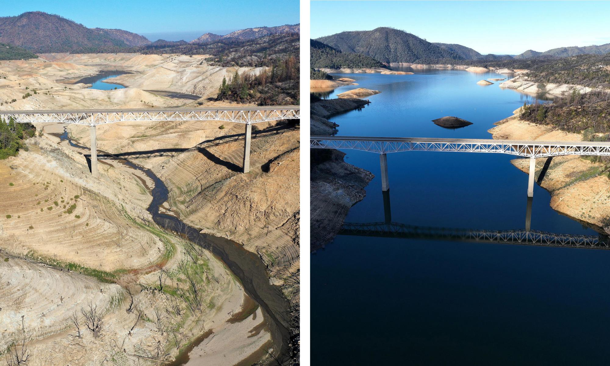
Houseboats sit in a narrow section of water in a depleted Lake Oroville.

Kamala Harris tours Lake Mead in Nevada in October.
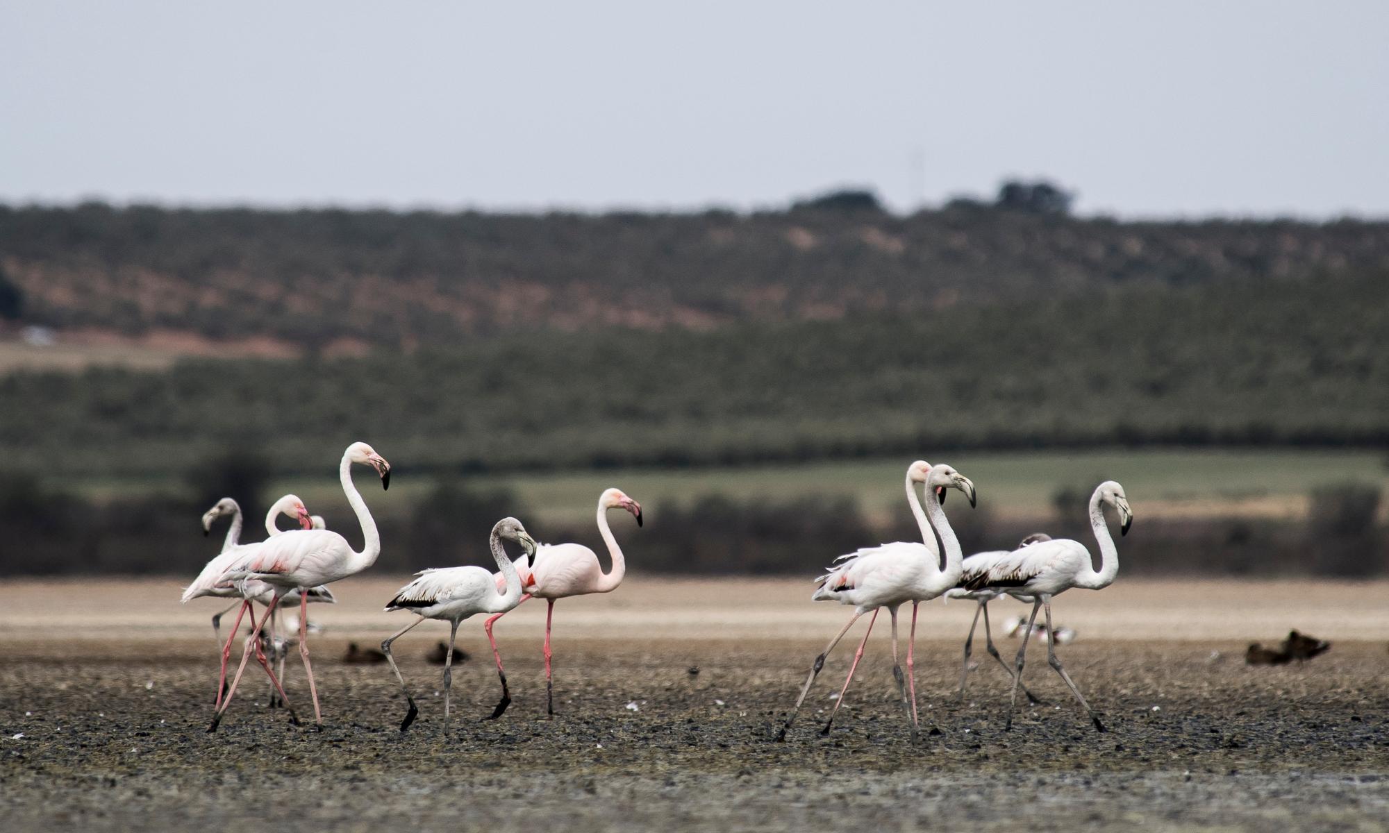
As of early December, roughly 80% of the American west was still experiencing “severe drought” as categorized by the US Drought Monitor. Nearly half still qualifies for the “extreme drought” category. The critically dry conditions left some communities with water shortages, fields were left to fallow, and reservoir storage in California – which has been among the states hardest hit by the catastrophe – fell to 60% of average.
This year, Lake Mead, which straddles Nevada and Arizona and is the largest reservoir in the country, sank to record-low levels and for the first time ever, and a water allocation shortage was declared for the Colorado River, which provides water for numerous western states and Mexico.
All of California remains under a statewide drought emergency and the state’s governor, Gavin Newsom, has called on residents to reduce water-use by 15%. “This is without precedent,” Newsom said at a news conference announcing the first two drought declarations in April, standing on the dried and cracked ground once covered by the waters of Lake Mendocino. “Oftentimes we overstate the word historic, but this is indeed an historic moment.”
The ebbs and flows of precipitation are normal in most western climates, especially in California. But human-caused warming has changed the stakes and added compounding characteristics. Rising temperatures limit the snowpack and also speed evaporation out of parched environments. That’s why, scientists fear, this isn’t just a disaster but a troubling trend.
“The drought in the American west is not a passing crisis,” Justin Mankin, a climate scientist and co-lead of the NOAA Drought Task Force wrote in a Washington Post op-ed in September. “It is the shape of things to come.”

A kayaker paddles in Lake Oroville in August as water levels remain low.

Empty boat slips sit on a dry lake bed at Folsom Lake Marina in May.

Rows of almond trees sit on the ground during an orchard removal project in Snelling, California in May.
High temperatures and drought also set the stage for intense and difficult-to-contain wildfires, which blackened more than 7.6 million acres across the US in 2021. Ancient trees and mountain towns were consumed by the fast-moving flames that spewed embers miles into the distance. The infernos grew large and violent enough to force thousands to flee their homes.
“This year’s fire season in the western US, and especially in three west-coast states, was the second exceptional wildfire year in a row” says Park Williams, a climate scientist at the University of California, Los Angeles. He cited the extreme drought and heat-wave events “which dried out fuels and made it easy for fires to escape our control in dense forested areas”.

The Caldor fire burns as a chairlift sits motionless at the Sierra-at-Tahoe ski resort in August.

The Bootleg Fire smoke cloud in Beatty, Oregon in July.

A firefighter sprays water while trying to stop the Sugar fire, part of the Beckwourth complex fire, in Doyle, California in July.

A firefighter prepares to battle the North fire from a backyard on Via Patina in Santa Clarita, California.

A satellite image of fires raging in California in August.

The remains of homes and businesses that were destroyed by the Dixie fire in Greenville, California.

Firefighters wrap the historic General Sherman Tree, thought to be up to 2,700 years old, in fireproof blankets in the Sequoia national park in September.

The Windy fire blazes through the Long Meadow Grove in Sequoia national park.

Fire consumes a home as the Sugar fire, part of the Beckwourth complex fire.

The Caldor fire approaches South Lake Tahoe in August.
Record-breaking heatwaves – hot enough to cook small sea creatures alive along the shores of the Pacific north-west this summer – wreaked havoc on residents, agriculture, and infrastructure. Hundreds of people perished during the dangerously-high temperatures. Across the US, 18% of the country broke heat records and summer temperatures were 2.6F above average, according to Noaa.
Climate models indicate that these extreme events could become more common by mid-century and there could be up to 30 big heatwaves a year. The norm now is between four and six. “That’s a huge difference,” Ostoja said. “That basically means it is going to be that hot all the time.”
They are also expected grow in size, impacting more people and places, according to research from Bradfield Lyon, a professor at the Climate Change Institute at the University of Maine.
“By mid-century, the spacial size of heatwaves in the US are expected to increase between about 50% to 80% from what they are in the current climate,” he said. “The frequency will increase, the duration will increase, as well as the intensity.”

A thermometer at Badwater Basin in Death Valley national park in July.

People at a cooling station in Portland in June.

A man rests at Willow’s Beach, British Columbia, during the ‘heat dome’, in June.

The sun shines near the Space Needle in Seattle in June.

A dead chinook salmon floats in a fish trap on the lower Klamath River in Weitchpec, California, in June.
While much of the west remained mired in drought through the autumn, some areas of the southwest, including Arizona and New Mexico, were drenched between June and September. The heavy rains tampered fire threats but also caused deadly flash floods and debris flows.
The Pacific north-west was also pummeled by downpours. Residents in western Canada and Washington state had to leave their homes as the waters rose. Water treatment facilities became overwhelmed in the city of Merritt in British Columbia, where officials called for evacuations due to “risk of mass sewage back-up and personal health risk”. The warnings came mere months after the last evacuations issued during the summer as wildfires laid siege on nearby towns. The province also endured punishing heatwaves that broke records and claimed hundreds of lives across the region.
Northern California was also hit hard by two rain storms that both left behind submerged streets, downed trees and power lines, and crumbling hillsides. Evacuations were ordered near burn scars from recent years where the danger of debris flows was high. Unhoused residents bore the brunt, as tents and shelters were overcome by the rains. Photojournalists who documented the scene at one waterlogged encampment in Santa Cruz, California said it looked “like a nightmare”.

Heavy rain in LA in October.

Heavy waves break against a sea wall in Depoe Bay, Oregon, in October.

Crews work to upright an overturned truck on the Richmond-San Rafael Bridge in Richmond, California in October.

Rocks and vegetation cover Highway 70 following a landslide in the Dixie fire zone in October.
Strong winds whipped up harrowing dust storms across the central US in December gusting more than 100 mph. Driven by high temperatures, said the unusual conditions were reminiscent of the Dust Bowl that devastated the region in the 1930s. High wind warnings stretched from New Mexico to upper Michigan.

A storm cloud of dust in Niwot, Colorado in December.

An overturned truck pushed high power lines over along Highway 93 in Superior, Colorado in December.
The extreme events that defined 2021 were destructive and devastating – but scientists hope they serve as warnings against a future that can still be avoided. Ostoja, from the USDA, likened humanity’s approach to climate change as a frog sitting in water that’s slowly starting to boil. But when disasters strike, it’s more difficult to look away.
“At least the extreme events kick that a little,” he says, “and my hope is that that’s what we start paying attention.”